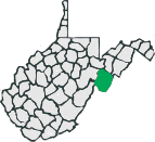
Pendleton County Rides:
There are currently two routes listed for Pendleton County, but there are opportunities for more. The Spruce Knob climb is one of the few out and back routes listed on this site, but it would better be classified as an up and down route. The climb to Spruce Knob probably isn't the hardest climb you could find in West Virginia, but is probably the longest. Alter you get there, you can look forward to the 11 miles of descending.
Disclaimer
The listing of routes on this site is not a guarantee of the safety of the route. Cycling has inherent risks and riders skills vary. Traffic conditions vary by time of day, season and local events. Road conditions can vary and change and may change dramatically over one winter season. Riders need to ride within their capabilities and be alert for road hazards and traffic at all times.
Copyright Notice:
This site, maps, photos and all materials created for this site are copyright of the author unless otherwise noted. They may NOT be posted on other sites or reproduced for sale or profit, without specific permission of the author. However, the maps and turn lists may be down loaded for personal, non profit use.
 After rainstorm.

 Photo by Tabitha Jones
 Looking East from Spruce Knob
 1
1 2
2 3
3 4
4 5
5 6
6