Franklin - Upper Track Loop
Overview
 Distance: 33.9 mi
Total vertical climb: 3,100 ft.
Surface: Paved
Feet climbing per mile: 91
Rating: 3.2
Location: This loop ride is in central Pendleton County, taking in the county seat of Franklin in the south and touching Upper Track at the northern end. Franklin and Upper Track are good starting locations for the route. Starting in Upper Track, gives you more assurance of finding a store open in Franklin for a mid ride break and refill.
You can add a few miles to this ride by going out to Co. 12 when taking US 33 out of Franklin, and heading up Troublesome Valley. This adds 3.2 miles on route 33, which can have traffic at times and part of it is climbing.
PDF Map and Turn List
Facebook Slideshow of route.
General Route Description
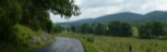
This loop travels mostly through farm country and some forest. Definitely not a flat route, but most of the climbs are long, but do not have steep gradiants.
Route 33 leaving Franklin can have high speed traffic. Taking the shorter route, gets you off of Rt. 33 at a fairly flat ride out of town. A very scenic route with some great vistas dropping down to Upper Track. Going on to Troublesome Valley involves a climb on route 33 before turning onto Co. 12.
Franklin to Upper Track: Leaving Franklin on U.S. route 33 heading north you can expect some traffic but you you leave at route 33 at 2.9 miles onto County 1. After turning off of US 33 onto Co. 1, the next few miles will be on rural back road with little traffic until you loop back to US 33 again. Co. 1 (Kiser Gap Road) has more shade than Co. 12 if the weather is hot. You travel uphill for about 6 miles before descending 6 miles to Upper Track. Crossing the South Branch of the Potomac River, you arrive at US 220.
Upper Track to Franklin: The route goes left in Upper Track on US 220, however you may want to detour right here for about a quarter mile in Upper Track, where there is a general store. This is a local store, not a chain, and may not be open on Sunday.
Going left on 220 for only 2/10 of a mile, you turn right onto Co. 8. Co. 8 starts out passing through a narrow gorge before opening up into a wider valley. The valley is mostly farms and provides little shade. On Co. 8 you are generally climbing until you reach U.S. 33 but there are a couple rolls. At the end of Co. 8, you turn left on U.S. 33 and descend into Franklin and the finish. This part of 33 does not have as much traffic as the part out of Franklin, plus you will be rolling at a higher speed on this downhill section. Arriving at the US 220 intersection, you take a right for the last mile to the finish.
Water and Food:
Franklin provides several opportunities for food and water. There is a local store in Upper Track (short right detour from the route), but may not be open on Sunday. On Co. 8, there is the trout hatchery on the right and you can probably get some water here if necessary.
Items of Interest
About five miles after turning onto Co. route 8 near Upper Track, you will pass the Reeds Creek Fish Hatchery. If the gate is open, you can go in and view the fish in the tanks. You can probably also obtain some water here if there are staff around.
Upper Track was the site of Fort Upper Track, built in 1756. It was attacked and destroyed in 1758 and eightenn militiamen wre killed.
The Cunningham Clevenger House in Upper Track is on the National Register of Historic Places. It is 2.4 miles off the bike route, but if starting in Upper Track, would be worth checking out.
Lodging and Camping
The Tourism link below lists several bed and breakfast and cabin rental opportunities in the county.
Local Sources
There are restaurants in Franklin. It is a charming little village that you will want to take a little time to explore.
Disclaimer
The listing of routes on this site is not a guarantee of the safety of the route. Cycling has inherent risks and riders skills vary. Traffic conditions vary by time of day, season and local events. Road conditions can vary and change and may change dramatically over one winter season. Riders need to ride within their capabilities and be alert for road hazards and traffic at all times.
Copyright Notice:
This site, maps, photos and all materials created for this site are copyright of the author unless otherwise noted. They may NOT be posted on other sites or reproduced for sale or profit, without specific permission of the author. However, the maps and turn lists may be down loaded for personal, non profit use.


 1
1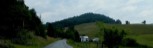 2
2 3
3 4
4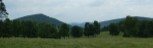 5
5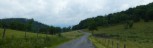 6
6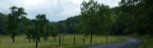 7
7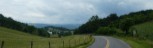 8
8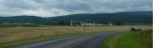 9
9 10
10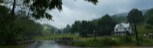 11
11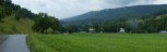 12
12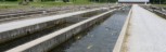 13
13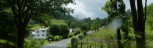 14
14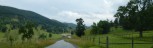 15
15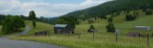 16
16