Overview

There are four rides listed on this site in the area covered by the area map, but the roads in the area provide multiple other options for great rides. The posted rides can provide a guide for learning the area, and then you can use the area map for devising your own routes.
Riding in this area is characterized by relatively flat roads along the river and creek valleys and rolling terrain along the ridges and upland areas. The transitions between the valleys and upland area can feature climbs with some very steep sections. Even the upland areas can have some short steep ramps to climb.
The climbing however, is rewarded with great vistas from most of the upland roads. Since most of the flat land has been cleared for farming, you often have unobstructed views for miles into the distance. There is about a 500 foot average elevation difference from the stream valleys to the upland areas. In the valleys you are usually riding alongside crop and pasture lands. The upland features more hay and pasture. The steep hillside are usually covered in forest.
U.S. Route 219 skirts the Southwest corner of the area and has the most traffic and is generally avoided by area cyclist. Two State routes, 12 and 122, bisect the area. Route 12 runs North - South and has moderate traffic at most times. Route 122 runs East -West and has lighter traffic and follows Indian Creek for much of distance in the area. The other paved roads in the area are county routes and generally have light traffic. The county routes vary from 2 lanes striped, to single lane (most common) requiring vehicles to put right side tires on the gravel to pass.
Knowing that some cyclist seek out climbs for the challenge, others try to avoid them, and some just want to be prepared, here is a listing of some of the more testy climbs in the area in no particular order. On the first map, the steeper climbs are designated with a thick red arrow - . Remember that “average1” means you will have gradients of more and less on the climbs.
Kibble Hill West Side Climb on Co. 27 from Red Sulphur Springs. 1.1 miles total averaging 7%. Average 9.5% for first 0.6 miles.
Kibble Hill East Side Climb on Co. 25/2 from Co. 25 on Hans Creek. 0.8 miles, average 7%, 0.4 miles averaging 9%.
Baker Hill Climb on Co. 19 from route 122. 0.9 miles, 8%, 0.5 miles 9.8%
Wikel Climb on co. 23/7 from route 122; 0.9 miles, average 8.6%. 6% first 0.4 and 12% last 0.5 miles.
Blue Lick on Co. 25/5 to Co. 27; 0.4 miles, average 9%. 12.5% first 0.2 and 5.8% last 0.2 miles
Ballard on Rt. 12 South form Red Sulphur; 1.3 miles, 6.5% average, 8.6% last 0.8 miles.
Route 122 West from Indian Creek toward Forest Hill; 0.6 miles, average 8.5%, 10% for 0.5 miles.
Routes listed on this site in the area.
- Indian Mills Loop (36.3)
- Indian Mills - Wikel Comb (62.2)
- Red Sulphur Springs Loop (21.7),
- Wikel Loop (20.7)
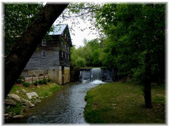
Favorite Sections: I love the whole area, but riding up Hans Creek, across Orchard Road (Co. 33), going to Bozoo and Marie are always highlights for me. The Lillydale area with the covered bridge is fun, cruising down 23/5 along Back Creek and stopping at Cooks Old Mill outside of Greenville are all highlights of riding in the area.
| Ballard | 2.127 |
| Bozoo | 2.214 |
| Coulter Chapel | 1.932 |
| Forest Hill | 1.931 |
| Greenville | 1.702 |
| Indian Mills | 1.525 |
| Lillydale | 1.793 |
| Marie | 2.065 |
| Orchard | 2.152 |
| Red Sulphur Springs | 1.540 |
Location
The area covered by this map is in Southwestern Monroe, and Eastern Summers Counties. The nearest incorporated towns are Peterstown, Hinton, Alderson and Unioin..


 1
1 2
2 3
3 4
4 5
5 6
6 7
7 8
8 9
9 10
10 11
11 12
12 13
13