Parsons - Kerens Loop
Overview
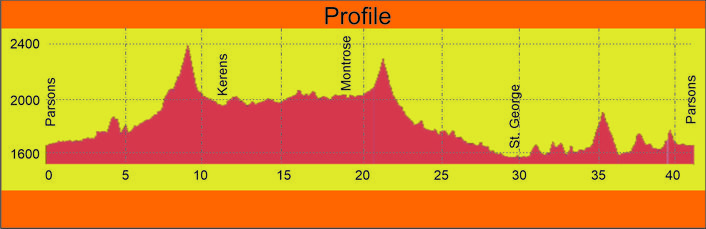
 Length: 41.1 Miles
Climbing: 2,950 Feet
Climbing Per Mile: 72
Rating: 3.5
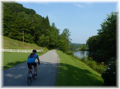
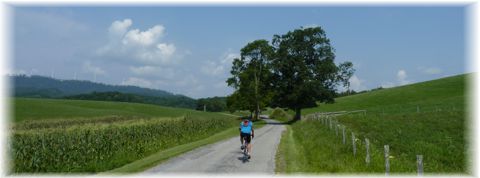
Location: This ride is in southern Tucker and northern Randolph Counties and is another beautiful route through farm county and forest. The communities of St. George and Parsons are on the route. St. George was the original county seat of Tucker County.
This is one of my favorite rides. The scenery is just outstanding. At 72 feet per mile, there is plenty of climbing on the route. There are three significant climbs on the route, the longest being the 1.7 mile climb over Cheat Mountain between Shavers Fork and route 219. These climbs are through forest and therefore shaded from the Sun during hot weather. The flatter parts of the ride are through farm land and provide little relief from the Sun.
I am generally doing the route from Horseshoe Campground, which adds another 8 miles of rolling terrain to the ride.
For a longer ride option check out the Elkins Lollypop that incorporates this loop within the ride.
Water and Food: The description and turn list starts in Parsons, which is the best source of food and water. You might consider starting at another point on the ride such as Israel Church, to make Parsons a mid ride break. There is a Patriots Four store at the intersection of routes 38 and 72 at mile 29.5, but they are not always open. The one dependable water source is in the small community park at the end of the bridge over the Cheat River at mile 30. There is a public water faucet that usually has a hose attached to it, used by locals to get drinking water. There are also restrooms there that may or may not be open. In the past, I have often stopped at the St. George Medical Clinic to top off my bottles, but they are closed on Sunday and public access is also restricted due to COVID 19.
PDF Map and Turn List
Ride with GPS of the route.
Facebook Slides show of route.
General Route Description
 Parsons to U.S. 219. Starting at the Allegheny Highland Rail Trail parking behind the old train station, you head South toward Elkins on the trail. Be ware of root humps on the rail trail. You soon arrive at the Corricks Ford Battlefield site. You will want to take the time to read the interpretive signs. Past the Corricks Ford site, you come to the Kingsford Charcoal Plant. with its huge pile of wood chips. I've always loved the smell of wood chips. Be cautions of trucks entering and leaving the plant. Continuing on the trail you will arrive at Porterwood, where a there is a kiosk and more trail parking. You will come alongside County 39. At the kiosk, you will do a 180 turn onto route 39, which leads you up Shavers Fork of Cheat. This is the route the Confederate Army took to Corricks Ford. The road here skirts the valley along the edge of the mountain with numerous rollers. 2.4 miles from Porterwood, the road make a sharp downhill right turn and comes to an intersection. Route 39 continues up river to the left and County 47 comes in from straight ahead. You want to continue straight onto route 47 past Irons Chapel.
Route 47 begins as a gentle upgrade along Pleasant Run until to come to the long climb (1.7 miles) of the ride. The climb starts out fairly reasonable with 5-7% grade before ramping up to 8-10% nearing the top. Cresting the top, you have a nice rollout down Wilmoth Run to the intersection with US Route 219, passing under Corridor H on the way.
US 219 to State 38: Continuing straight across US 219 onto County 3, the next few miles will be through beautiful pasture land. You will shortly take a left onto narrow Co. 3/3 and a short climb. 1.7 miles will bring you to Co. 7 where you take a right and after 0.8 miles another right onto Co. 3/1. This is the southern point of the loop, and you now head north. You are on Co. 3/1 that becomes Co. 3 that becomes Co. 1, it all becomes appears as one road when riding up the valley on a pretty flat profile. After passing the small community of Montrose the country becomes more forested and then you make a sharp left and begin the 1/2 mile climb to the county line. Crossing the crest, you begin a steep descent with SHARP turns at the top with a lessening gradient and straighter profile nearing the bottom. 23 intersects county 21 and you bare right and continue on 21 through the forest. You are now riding on part of the cross country American Discovery Trail. When you near Route 38, beware of the medal open deck bridge you have to cross at about the 28 mile mark, just before reaching route 38.
Route 38 to Parsons: Taking a right on 38, you have a 1.3 mile gradual downhill run to Route 72 and the Cheat River. The Patriots Four store is at this intersection. Taking a right on 72, you go 0.3 miles and take a left across the Cheat River to St. George. At the far end of the bridge is the small on the right where you will find a public water faucet, and rest rooms that may or may not be open. Take a right in St. George on county route 1 and past the St. George Academy and the St. George Medical Clinic. Passing the clinic, you will be traveling along the edge of the Cheat River valley with rolling terrain and a couple short steep ramps. After passing the roads to Horseshoe Campground and Sugarland Road (Bare sharp right. Sugarland Road goes straight.) you will come to a sharp switchback that begins the last big climb of the day. This is a pretty steady climb with no severe ramps. Topping out, you begin a steep descent with a sharp turn in the middle. Watch for rocks in the road near the bottom.
Reaching the bottom, you come out again along a short beautiful stretch of Cheat River. Leaving the river as it goes to the other side of the valley you have some more short steep rollers before crossing the river again and coming back to route 72. Take a left on route 72 fo r the final 1.7 miles to Parsons. When arriving in Parsons, I cut left toward the Five Rivers Campground and take the back streets to the finish.
Food and water sources.
The description and turn list starts in Parsons, which is the best source for food and water. You might consider starting at another point on the ride , such as Israel Church, to make Parsons a mid ride break. Thre is a Patriots Four store at the intersection of routes 38 and 72 at mile 29.5, but they aare not always open. The one dependable water source is in the small community park at the far end of the bridge over the Cheat River at mile 30. Thre is a public water faucet that usually has a hose attached to it, used by locals to get drinking water. There are also restrooms there that may or may not be open. In the past, i have often stopped at the St. George Medical Clinic to top off my bottles, but they are closed Sat. PM and Sunday and public access has been restricted with COVID 19.
Points of Interest
The Corricks Ford Battlefield is the major point of historical interest along the route. There are several informational signs concerning Corricks Ford along the route. From Parsons to Rt. 219, the bike route follows the route of the Confederate retreat and Federal pursuit, though in the opposite direction as described in the turn sheet. Shavers Fork and the Cheat River provide geological interest.
Parsons is the county seat of Tucker County, and has three building listed on the National Registry of Historic places. If you have the time and legs, you can check out the Alleghany Highlands Trail in the other direction thru Parsons.
Disclaimer
The listing of routes on this site is not a guarantee of the safety of the route. Cycling has inherent risks and riders skills vary. Traffic conditions vary by time of day, season and local events. Road conditions can vary and change and may change dramatically over one winter season. Riders need to ride within their capabilities and be alert for road hazards and traffic at all times.
Copyright Notice:
This site, maps, photos and all materials created for this site are copyright of the author unless otherwise noted. They may NOT be posted on other sites or reproduced for sale or profit, without specific permission of the author. However, the maps and turn lists may be down loaded for personal, non profit use.


 Tucker Cty. 1
 Tucker Cty. 1

 1
1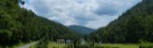 2
2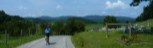 3
3 4
4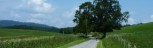 5
5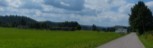 6
6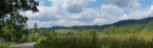 7
7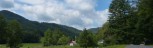 8
8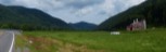 9
9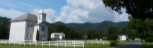 10
10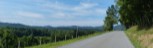 11
11 12
12 13
13