Hillsboro - Lobelia Loops
Overview
The Hillsboro, Lobelia area has long been a favorite road riding destination. The area is beautiful and though these rides have plenty of climbing, you are rewarded with outstanding vistas. You will want to take the short detour into Droop Mountain Battlefield State Park to view the Big Levels from the lookout tower. If you are doing Section D, you will want to take the 100 yard detour at the end of Locust Creek Road, to ride you bike through the Locust Creek Covered Bridge.
Below are various route options ranging from 11.4 miles and 885 feet of climbing to 45 miles and 3,969 feet of climbing starting in Watoga State Park. Options that include Lobelia, not only have the second climb up the back side of Droop Mountain, but have 4 steep ramps to go over between the climbs of Droop.
PDF Map and Turn List
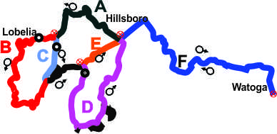
The graph below shows the route options with letters indicating the different sections. The route descriptions will indicate which route sections are use for the specific route, in the order they are covers. All routes start in downtown Hillsboro with the exception of the Assault on Droop Mountain.
General Route Descriptions
 Hillsboro Loop - Sections A,C,E
Length: 11.4 Miles
Climbing: 885 Feet
Rating: 1.0
Climbing per Mile: 77.6
Ride with GPS file of route created by George Cook
This route features a two mile climb of Droop Mountain, before a flat ride across the mountain to Droop Mountain State Park and then a long curvy steep descent on US 219 with a final flat run back to Hillsboro.
- 0.0 Start Intersection of US 219 and Lobelia Road
- 4.9 Left on Rt. 22
- 7.1 Left on US 219
- 7.6 Left into park to go to the Lookout Tower. Worth the short detour. Water fountain at parking lot. Continue straight and begin long curvy downhill.
- 11.4 Finish
Hillsboro-Lobelia Loop - Sections A-B-E
Length: 17.9 Miles
Climbing: 1,968
Rating: 1.9
Climbing per Mile: 110
Ride with GPS file of route created by George Cook
This route features two climbs of Droop Mountain and four short steep climbs in between. Note that the substitution of section B for section C in the above ride , adds 6.5 miles and 1,083 feet of climbing or 167 per mile on section B.
- 0.0 Start at US 219, Lobelia Road Intersection.
- 4.9 Continue straight and begin a steep curvy downhill on narrow road. Be ready for oncoming traffic and watch out for gravel in turns. There are two U turns on the descent.
- 10.9 Bare left at this sharp left downhill turn to continue on Rt. 29. Get ready for the next climb of Droop Mt.
- 13.1 Left on US 2129. Begin flat cruise across mountain.
- 14.1 Take this second entrance into Park to go to lookout tower. Worth the detour and there is a water fountain in the parking lot.
- Continue straight and begin long curvy downhill before final slightly uphill run into Hillsboro.
- 17.9 Finish in Hillsboro
Hillsboro - Droop - Locust Creek Loop - Sections A-C-D
Length: 17.8 miles
Climbing: 1,279 feet
Rating: 1.5
Climbing per mile: 72
Start in downtown Hillsboro at US 219 Co. 29 Locust Creek Road intersection. This route does not include the hilly section B, but there will be a couple short climbs coming back into Hillsboro from the Locust Creek Covered Bridge.
- 0.0 Start
- 4.9 Left on Co. 22, Russell Scott Rd.
- 7.1 Left on US 219
- 7.4 Take Second entrance to Park to go to the lookout tower. Worth the short side trip. There is also a water fountain at the parking lot.
After the tower continue on 219 and begin steep curvy downhill. You turn onto Co. 20 before you reach the bottom of the hill.
- 9.0 Sharp Right onto Co. 20. Locust Creek Rd.
- 12.1 Left and an immediate Left onto Co. 31/9. Option to continue on Co 39, but 31/9 is more scenic with less climbing.
- 14.0 Straight at jct. with Co. 31.
- 17.8 Finish
Lobelia Loop Sections A-B-D
Length: 24.4 Miles
Climbing: 2,329 Feet
Rating:2.4
Climbing per mile: 95.5
Ride with GPS file of route created by George Cook
Route features two climbs of Droop Mountain and trip down Locust Creek.
Start in Hillsboro at Jct. of US 219 and Co. 29 Lobelia Road
- 0.0 Start
- 4.9 Bare right to continue on Co. 29. Road narrows and begin a steep downhill with a couple U turns.
- 10.9 Bare Left in sharp left downhill turn to continue on Co. 29. Second climb of Droop Mt. coming up.
- 13.0 Left on US 219
- 14.1 Second entrance to Park. Take this entrance to go to Lookout Tower. View is worth the detour. There is also a water fountain in the parking lot to top off your bottles. Continue on US 219 to continue bike route. Begin curvy steep downhill section. You turn onto Co. 20 BEFORE reaching the bottom.
- 15.6 Left turn onto Co. 20, Locust Creek Rd.
- 18.7 Left and another immediate right onto Co. 31/9. Locust Creek Covered Bridget it just to the right at this intersection.
- 20.6 Straight onto Co. 31
- 24.4 Finish
Assault on Droop Mountain. Sections: F-A-B-D-F
Length: 45.8 miles
Rating:4.1
Climbing: 3969
Climbing per Mile: 87
Ride with GPS file of route created by George Cook
This is a route I introduced for the Mountain State Wheelers bike club's annual Fall weekend. It is a very scenic, but tough ride.
Start at parking lot at the entrance of Beaver Creek Campground, Watoga State Park.
- 0.0 Start.
- 0.1 Right out of the campground.
- 0.6 Left onto Co. 21/4 to go thru the Park. Start with a short steep climb and then a long gradual downhill to the river.
- 2.9 Bare right at the Lake/Park Office.
- 6.4 Right to continue to Seebert.
- 7.1 Cross River and follow Co. 27 to U.S. 219. Steep climb out of Seebert to US 219..
- 9.4 Left on US 219
- 10.7 Right on Co 29, Lobelia Road
- 15.6 Straight to continue on Co. 29. Road Narrows. Begin steep twisty downhill with 2 U turns. Watch for gravel on the road.
- 21.6 Bare left in sharp downhill left turn to continue on Co. 29. Second climb of Droop Mountain coming up.
- 23.7 Left on US 219
- 24.8 Second entrance to the Park. You can take it to go to the lookout tower where this is a water fountain at the parking lot. You earned the chance to enjoy the view.
- Continue on US 219 and begin steep, twisty downhill. Turn onto Locust Creek Road before the bottom.
- 26.3 Sharp Right turn on a down grade.
- 29.4 Left and an immediate Left onto Co. 31/9. Locust Creek Covered bridge is just to the right at this intersection.
- 31.4 Straight onto Co. 31
- 35.1 Right on US 219 back in Hillsboro.
- 36.3 Right onto Co. 27 to return to Seebert.
- 38.6 Recross Greenbrier River at Seebert.
- 42.9 Left onto Co. 21/3 at Park office.
- 45.1 Right to return to campground entrance.
- 45.7 Right to Campground
- 45.8 Finish
Disclaimer
The listing of routes on this site is not a guarantee of the safety of the route. Cycling has inherent risks and riders skills vary. Traffic conditions vary by time of day, season and local events. Road conditions can vary and change and may change dramatically over one winter season. Riders need to ride within their capabilities and be alert for road hazards and traffic at all times.
Copyright Notice:
This site, maps, photos and all materials created for this site are copyright of the author unless otherwise noted. They may NOT be posted on other sites or reproduced for sale or profit, without specific permission of the author. However, the maps and turn lists may be down loaded for personal, non profit use.


