


 1
1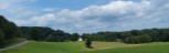 2
2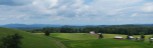 3
3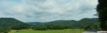 4
4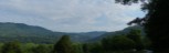 5
5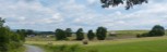 6
6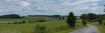 7
7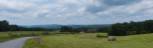 8
8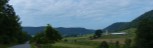 9
9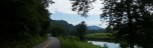 10
10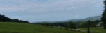 11
11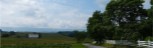 12
12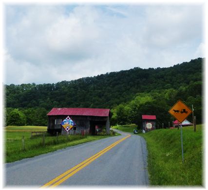
General Description
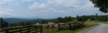
This is s beautiful ride, with little traffic. The ride is through mostly farm country, with a little through forested areas in the Bluestone Wildlife Management Area. You have upland farms in the Marie, Orchard, Ballard and Bozoo area, and valley farms along Indian, Hans and Blue Lick Creek. Short sections are on 2 lanes striped state highways 12 and 122, but traffic is light on these roads other then during b commuting times. The rest of the route is on un-striped roads, many are single lane pavement requiring cars to run on the berm to pass. The two really steep grades on the designated route is the 1+ mile descent of Baker Hill on route 19, and the 0.4 climb (8.8% Avg.) on 25/5 at the end of Blue Lick Creek to route 27. There is a steep ramp on Co. 27 just before Bozoo, and a couple steep ramps on and Indian Creek Road also.
In addition to the basic route, a glance at the map will show there are plenty of options to the listed route to add a little variety when riding in the area. Of the optional routes, starting from North to South:
- County 17/2 between Marie and State 122,will give you a climbing challenge in either direction, but especially when heading south.
- State 122 between State 12 and Cty. 17/2, has a couple short climbs, and between 17/2 and Cty. 23, a long fairly steep descent. .
- Cty. 23 follows Indian Creek and is a flat cruise between State Route 122 and 12.
- Climbing Kibble Hill, whether on 27 out of Red Sulphur Springs, of from Hans Creek on 25/2 is a challenge, with the climb out of Red Sulphur being the most challenging. .
- County 27/2 is a viable alternative to going to Orchard before heading to Ballard, but has a little more climbing than the designated route.
- From Bozoo, taking 24/2 (becomes 23/7 in Summers Co.) rather than the designated 24/3 will provide a shorter and flatter option, but just as scenic route. In reverse, you have a steep climb leaving Cty 23/4 on Cty. 23/7.
Route Description
Start:
The route description as well as the pdf turn list starts at Forest Hill at the intersection with Cty. 21/1, Seminole Road. At the intersection there is a church,and also another church 0.1 miles out Seminole Road that you can park at. Other options to start from are at Ballard along Route 12 in the southern portion of the route are a couple of churches. At the intersection of State Route 122, and Monroe Cty. 25, there is parking space for a couple of cars. At Indian Mills, there is parking at the Bluestone Wildlife Management Office as well as a parking area down by the bridge over Indian Creek.
Forest Hills to Route 122: After only 0.1 miles on route 12, you bare right on County 21/3 Forest Hills Road. 21/3 rolls a little, but not much climbing. After 0.7 miles you merge right onto Cty. 12/5 on a slight downhill. 12/5 offers a fairly flat ride across to Marie. Some nice vistas on the way. At Marie you take a right on Summers Cty. 17, Little Stoney Creek Road. You will want to stop and take a walk thru Emma Jean's store which makes up the business district of Marie. Just past the store the Ben Voss Rd. 17/2 take off to the right, but you want to continue straight on Co. 17. Enjoy the vistas as you arrive at the Summers/Monroe County line where the road becomes Monroe 19. Just past the county line, take a right onto Baker Hill Road to follow 19. You immediately begin a STEEP downhill for more than a mile as you drop into the Indian Creek drainage.
State Route 122 to Orchard: Turning left onto route 122 from Cty. 19, you start up the Indian Creek drainage. For the next 10 miles you will be riding along Indian Creek, Hans Creek and Blue Lick Creek, through some of the best farming property in the county. A few of the farms along this section have been in the same family since the late 1700's. 1.8 miles on route 122 brings you to Cty. 25, Hans Creek Road. Take a right and cross Indian Creek on an open deck medal bridge. Enjoy the scenery as you travel along the undulating road. When you cross Hans Creek again, you take a left at the end of the bridge to continue up Hans Creek. Eventually Hans Creek veers off to the left and you continue to follow the paved road along Blue Lick Creek. Just past the Larew Cottage, you cross another open medal deck bridge. As you reach the upper end of the valley, the road makes a right across the narrow valley and begin a 0.4 mile climb of 7-9% up to the junction with Cty. 27. Taking a right on Cty 27, you follow the a ridge up to Orchard.
Orchard to Bozoo: At Orchard you take a left onto Orchard Road, Cty 33, which continues along the high ground with great vistas to Ballard. Arriving in Ballard, you take a left on state route 12. There is a dairy bar at the intersection where you can get a water bottle filled at little or no cost. Just after turning onto route 12, there will be a little store on the right, your only option for food and water after leaving Marie. Past the store you start downhill, but look for the red and white building that houses the volunteer fire department. Take a right in front of the building on Cty.24, Pinhook Road. Route 24 is undulating and has a fair climb on it before arriving at the intersection that constitute Bozoo, which is also the high point of the ride.
Bozoo to Forest Hills: At the intersection, you continue straight to go onto Cty. 24/3, Shanklins Ferry Rd.(County 24/2 goes right at this intersection is also a shorter, flatter and just as scenic alternative route.) Shanklins Ferry Rd. becomes Summers Cty 23/6 as you begin to descend into toward the New River. After a fairly steep descent you arrive at the intersection with Cty. 23/5, Indian Mills Road. You take a right on Indian Mills road and begin a short but steep climb (12%) before a short flat cruise thru farm country again. Another descent takes you by a campground access and another short climb. At the intersection withe Cty. 23/7 you continue straight and you have one more descent with a sharp turn at the bottom that usually has gravel in the turn, and a small climb before the final descent to Indian Creek at Indian Mills. After crossing Indian Creek (bridge deck is very rough), the ranger station is on the left. From the station it is 2.9 miles of rolling terrain out to state route 12. Turning left onto route 12, you immediately begin climbing at 2 - 4% for a mile before ramping up to 6-7% up to the finish at Forest Hills.