Elizabeth Loop - An Oil Boom Loop
Overview
 Length: 55.9
Climbing: 2,431 Feet
Rating: 4.0
Climbing per Mile: 44
Overview: This is one of the flattest loop routes of this length I have found in West Virginia. A couple good climbs, interspersed with plenty of flat cruising. This area of the state is the location of one of the first major oil strike in America.
Location: This ride is in Jackson, Wirt, and Roane Counties. This is a relatively flat ride (WV Flat) with two climbs and some rolling terrain between Elizabeth and Palestine. This route can be accessed from Exit 146 (Silverton/Ravenswood) of Interstate 77.
Start: I start the ride at the Gilmore School because I'm coming from the Charleston area, There is also a church at Sandyville that makes a good starting point. Starting at New Ear/Sandyville area gives you a store at mid ride in Elizabeth and another at Reedy.
Getting there; From Charleston, take I-77 North 47 miles to the Silverton Exit. Take a right on Co. 56 and go 3.7 miles to Rt. 21. Take a left and follow Rt. 21 1.3 miles to New Era and the Gilmore School will be on your right.
From Parkersburg, take I-77 South and get off at Silverton exit 146. Left on Co. 56 Go 3.7 miles and take a left on St. 21. Go 1.3 miles and the school will be on the right. .
PDF Map and Turn List
Ride with GPS
Garmin Connect
Slides show of Elizabeth Loop
General Route Description
New Era to Elizabeth - Starting at Gilmore School on route 21 in Jackson County, you head north as it follows Sandy creek upstream to it source. Route 21 is flat till the final 1 1/4 mile climb up Limestone Ridge. The climb is mostly 7-9 % for the first mile and than eases up for the final 1/4 mile. At the top of the climb, you take a right onto County 1/1, Tucker Creek Rd. just before you would have crossed into Wood County (You do not enter Wood County on this ride.) Turning onto Tucker Creek Road, you roll 2 miles along the ridge before a STEEP descent down to Tucker Creek and the junction with County 1. You follow County 1 and Tucker Creek downstream to Elizabeth. Only a short 10% ramp near Elizabeth interrupts a pleasant cruise. On the outskirts of Elizabeth, you turn right on State Route 14.
Elizabeth to Reedy - From Elizabeth, you will follow Route 14 for the next 15.5 miles. Leavng Elizabeth, you follow the Little Kanawha River, but find more climbing in the next 3 1/2 miles as the road climbs the bluff above the river. Passing Palestine. Past Palestine, you will be following Reedy Creek on gently rolling roads. You enter Roane County a couple miles outside of Reedy. There is a store at Reedy, at the intersection with Roane County 1.
Reedy to New Era:- At Reedy, you will take County 1, Liverpool Road. From Reedy you are going upstream and have one fairly easy climb to Sandy Summit, climbing a little over 200 feet from Reedy. Shortly after topping Sandy Summt, you will cross into Jackson County, and Roane County 1 becomes Jackson County 13. From Sandy Summit, you will be going downstream along Right Fork. After 15.6 miles from Reedy, you intersect Route 21 at Sandyville. Taking a right on Route 21, you only have 0.7 miles to the finish at the school.
Items of Interest Along the Route:
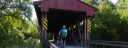
The Sarvis Fork Covered Bridge is just 9/10 of a mile North of Gilmore School. It is 2/10s of a mile off of the route on Co. 21/15. It can be seen from the route on the right heading North.
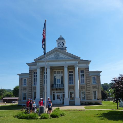
The Wirt County Courthouse is in Elizabeth. The courthouse if half a block off the route on Court and Washington streets.
There was strong southern sympathy in the area during the Civil War. This resulted in a lot of partisan activity, but the big event was the Jones - Imboden Raid on Burning Springs in May 1863.
Food and Water:
There are food and water sources in Elizabeth (25 miles) which is about the halfway point when starting in New Era. There is also a general store in Odaville, two miles from the start (see map) that has water and snacks, and a store at Reedy (41.5 miles).
There is are also convenience stores and a Dairy Queen at the Silverton exit of Interstate 77.
Disclaimer
The listing of routes on this site is not a guarantee of the safety of the route. Cycling has inherent risks and riders skills vary. Traffic conditions vary by time of day, season and local events. Road conditions can vary and change and may change dramatically over one winter season. Riders need to ride within their capabilities and be alert for road hazards and traffic at all times.
Copyright Notice:
This site, maps, photos and all materials created for this site are copyright of the author unless otherwise noted. They may NOT be posted on other sites or reproduced for sale or profit, without specific permission of the author. However, the maps and turn lists may be down loaded for personal, non profit use.


 1
1 2
2 3
3 4
4 5
5 6
6 7
7 8
8 9
9 10
10 11
11 12
12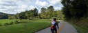 13
13 14
14 15
15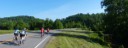 16
16 17
17