


 1
1 2
2 3
3 4
4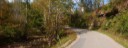 5
5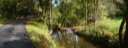 6
6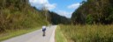 7
7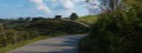 8
8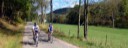 9
9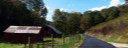 10
10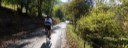 11
11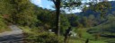 12
12General Description
Figure Eight Route
Taking a right out of the parking lot, you go 0.2 miles and then take a left before crossing the bridge and continue on this road with a rolling profile till you intersect State Route 36. Making a right on State 36, you roll past the Geary School and take the next left on Cty. 60 (Tariff Rd.). On Cty. 60 you are going upstream beside Ashleycamp Run for 1.5 miles till you reach its headwaters and the first climb of the day. This climb is only 0.024 miles long but averages 13.5% with a ramp of 17%. The next section of road till the Rt. 26 junction has fair to poor pavement, but low traffic. After this short, but tough climb, you are rewarded with 7 miles of downgrade along Sycamore Run to Linden before making the left turn onto Cty. 25 and starting a gradual ascent along Hayes Run for 3.6 miles to the intersection again with State Route 36. Here you have the option of taking a left on State 36 for a fast 3.1 miles downgrade to Looneyville, or taking a right, as indicated on the map, for the slower, but more scenic route via Flat Fork. Taking a right, you ascent for 0.2 miles before taking a left onto Cty. 36/12 (Flat Fork Rd.). Flat Fork road is a narrow, single lane paved road. I like this option as it is scenic and has VERY LITTLE traffic. It is 4.4 miles to Looneyville this way, 1.3 miles longer than Rt. 36.
At Looneyville, you take a right onto Rt. 36 and ascend along Vineyard Run for 1.1 miles before the 2nd. climb of the ride. This climb to Vineyard Gap is 0.4 miles in length and averages 9.1%. Arriving at the summit, you have a nice downhill run with a turn at the bottom. You continue on Route 36 and complete the upper section of the figure eight, as you pass the Geary School again. You continue pass where you previously turned left onto Tariff Road and in 1/2 mile you come to the 3rd and final climb of the route. The main part of the climb is only 0.3 miles long and averages 9%. After topping out the climb you have a straight downhill and flat rollout. The turn onto Cty. 29 is a hard Right in a left turn on State 36. Cty. 29 follows Big Sandy Creek downstream back to the finish.
Clockwise Direction
Start - Amma Park-N-Ride under the I-79 Bridge
Taking a right out of the Park-N-Ride, you bare left before crossing the bridge and then take the next left (Cty. 58) and begin climbing along Little Left Hand Creek. At the end of 58, you have a steep climb up to Vineyard Ridge and the intersection with Cty. 21. Taking a right on Cty. 21, you have rolling terrain along Vineyard Ridge out to Vineyard Gap. Taking a left State 36 you have a steep descent and after 1.5 miles you go left at the end of the bridge onto Stringtown-Poca River Road. It starts out along the headwaters of the Pocatalico River before turning up Flat Fork Creek. At the end of this 4.4 mile road, you have a climb up to State Route 36 again. You have traveled 12.3 miles to this point, and averaged over 90 feet of climbing per mile. From this point on, you only have two climbs to tackle to the finish.
After taking a right on route 36, you begin to descend and take an immediate (0.2 miles) left onto the Linden-Tariff road county 25, and continue down Hayes Run for another 5.3 miles to Linden. You make a hard right across the bridge and begin the gental ascent along Sycamore Creek. Unfortunatley, the pavement is very rough and patching for the next six miles (2017). After passing Tarriff you have a short steep climb and shorter steeper descent along Ashleycamp Run, and the intersection with route 36 again at 24.9 miles. Taking a left on route 36, you begin to ascent and are quickly on the final climb of the ride. Topping the climb, you have a fairly straight descent and nice rollout for the next couple of miles. You enter a long left turn and at the end you have a very sharp right turn onto Cty. 29 at 28.6 miles.You are on Cty. 29 for 5.5 miles as you follow Big Sandy Creek back to the start. At 34.1 miles you cross the bridge and complete the loop and continue straight for another 0.2 miles back to the finish at the Park-N-Ride.
Counterclockwise Direction
Start - Amma Park-N-Ride under the I-79 bridge.
Taking a right out of the Park-N-Ride, you cross under the Interstate and you continue straight at the first intersection across the bridge onto Cty. 29. Rt. 29 is a two lane road with good pavement that follows Big Sandy Creek upstream, for 5.5 miles to the intersection with State 36. Taking the sharp left onto Rt. 36, you continue a fairly flat, but slight upgrade section, for 2.4 miles before arriving at the start of the first climb of the day. The climb is 0.5 miles, averaging 7.6% with ramps up to 10% near the top. The descent has a couple gradual curves, but nothing severe. From the top of the climb, you descend for 0.9 miles, before making a very sharp right onto Cty. 60.
On Cty. 60 (Tariff Road) you are going upstream again beside Ashleycamp Run for 1.5 miles till you reach its headwaters and the second climb of the day. This climb is only 0.024 miles long but averages 13.5% with a ramp of 15%. The next section of road till the Rt. 26 junction has fair to poor pavement, but low traffic. After this short, but tough climb, you are rewarded with 7 miles of downgrade along Sycamore Run to Linden before making the left turn onto Cty. 25 and starting a gradual ascent along Hayes Run, for 3.6 miles to the intersection again with State Route 36.
Here you have the option of taking a left for a fast 3.1 miles downgrade to Looneyville, or taking a right as indicated on the map for the slower, but more scenic and less traveled route. Taking a right, you ascent for 0.2 miles before taking a left onto Cty. 36/12 (Flat Fork Rd.) . Flat Fork Road is a single lane road, so be prepared to stop for oncoming traffic. I like this option as it is scenic and has VERY LITTLE traffic. It is 4.4 miles to Looneyville this way, 1.3 longer than Rt. 36.
At Looneyville, you take a right onto Rt. 36 and ascend along Vineyard Run for 1.1 miles before the 3rd and final climb of the ride. This climb to Vineyard Gap us 0.4 miles in length and averages 9.1%. Arriving at the summit, you take a right, onto County 21 and have a rolling 1.4 mile ride out the ridge with great vistas, before taking a left on Cty. 58 (Little Left Had Road - no road sign here). At 1,171 feet, this is the high elevation of the ride. After 0.3 miles on Cty 58 you begin a steep curving descent so control your speed. Cty. 58 has sections of VERY BAD pavement. There is one section that is around a blind turn that can really catch you out, but it has little traffic and is the scenic option. After 4.7 miles on Cty. 58 you arrive at Cty 58/2 where you take a right and after 0.1 miles you take another right to return to the start.
Route Options:
- Newton and thru Hollywood - Scenic but road varied from good to very bad. Steep climb.
- 36/17 & 27/2 is an alternate from Left Hand for part of Tariff road, but has deteriorated in recent years.
- You can continue out Vineyard Ridge Road to U.S. 119 and take Amma Road from U.S. 119 6 to Amma. Adds a couple longer steep climbs plus additional miles.